Chuck78
-
Posts
327 -
Joined
-
Last visited
-
Days Won
2
Content Type
Profiles
Forums
Gallery
Store
Events
Everything posted by Chuck78
-

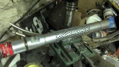
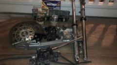
DIY muffler baffle after a loooooonnngggg time on the drill press!
Chuck78 posted a gallery image in Members Albums
From the album: Chuck
-
From the album: Chuck
-
From the album: Chuck
-
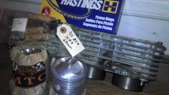
GS850 cylinder block and MTC Engineering 920cc piston kit!
Chuck78 posted a gallery image in Members Albums
From the album: Chuck
-
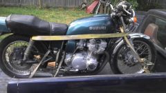
$725 and one hour later, my 1977 GS750 arrives home!
Chuck78 posted a gallery image in Members Albums
From the album: Chuck
-

From the album: Chuck
-
From the album: Chuck
-
Thanks! Glad we rode Saturday, so much rain today. Mountain biking at Chestnut Ridge can wait til another winter day when it's too cold for a motorcycle day trip
-
After some poking around, I think that an amazing trip would be to take this route but stay on 78 all the way to the other segment of Wayne National Forest (Wayne's Ironton Ranger District), and then link up with OH26, which sounds like one of the best best roads Ohio has to offer. Then maybe hit the southern portion of 555, which I think I remember reading was the best section of that road.
-
I will also add that the ridgetop views at many points on 78 especially near Burr Oak State Park were ABSOLUTELY PHENOMENAL! Wow! This portion of the Wayne National Forest area is somewhat lacking in scenery, as SE Ohio in general was almost completely clear cut during the late 1800's to provide wood fuel for the iron mining industry that was booming then. This ride was mostly still clearcut areas that now is used as farmland. Some forested areas, but not like Hocking. I really really have a soft spot for Hocking, especially after we got our preferred Hocking route tweaked to hit basically every awesome road in the region. Hocking trip map, 2 pages, map route displays only one page at a time. This ride was REALLY REALLY FUN, I highly recommend this route. The roads leading to Clearcreek were more than a good warmup off of 33. Clearcreek is such an incredibly scenic area that I had no desire to ride fast over the vastly varied pavement conditions, I was in awe over how beautiful the valley, creek, and rock formations were. Not really a high speed road anyways, lots of hikers, fisherman, pedestrians in general. Scenery makes up for it tenfold. http://goo.gl/maps/SM0by
-
Got off to a late start resulting in riding the last of the twisties in the dark, but had a great ride! The first half of the ride was the best, with some big hills and technical turns right off the highway (and gravel in lots of them for the first bit), and 78 was AWESOME, more memorable than 555 for me for sure, although 555 would have been a lot more fun if the sun weren't setting on us while riding on a road that had a lot of turns with a fair amount of gravel in them. Probably should have either stuck with the original south of I-70 portion of the Dream Ride 2012 route, or skipped the triangle/lower figure-8 portion of our route where we passed 555 on 78, made a right on 377, and then back north on 555. 377 was a repeat of some of the other moderate terrain we did, nothing too special. 555 was a well done tar and chip road , but still some graven here and there. heading back north on 555 about 1 mile before coming back up to 78 again, that part of 555 was really rad and turned back to nice pavement instead of tar and chip, but wasn't worth the extra 18 miles that we road just to hit that. North of 78, 555 was really good, but cars had kicked up too much gravel from the shoulder into the turns, so we couldn't ride it too hard. Should have just taken 78 East to 555 and made a left, or gone south on 555 for a mile and turned around if you wanted to hit some great hills and backtrack. 669 was just decent on the portions we rode. 668 /93/217/78 was a great route, take that and make a left (North) on 555, or else just keep going on 78, looks like 78 gets better again after a short farm stretch to 377. 78 in general I think would be a fun road to do in it's entirety. If we have any warmer winter days again, I'm going to try and do a Coshocton area ride. Have to help my buddy rebuild his anemic KZ650's carbs first though so he can keep up!
-
As in gravel, branches, & leaves? Or just that it's a real tchnical road?
-
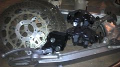
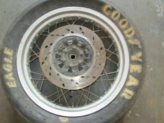
My wife traded her first bike, a big heavy Honda SilverWing, for a ratty old 77 GS550B just like in the picture, but flat black rat look on the fender and tank. Wrenching on that got me into ditching my CB750 and Royal Enfield plans for a GS750, after familiarizing myself quite well with the old Suzuki's! I just yanked off a GS650 shafty top end (cylinders pistons head cams) from Rice Paddy to swap onto her original 1977 550 with worn piston rings (anyone need a nice 78 550 engine?). Going from a tweaked (jets+DynaIgniton+K&N+glasspacks) 550cc 8.8:1 compression 60-ish hp engine that's real fun to ride, up to 673cc's 9.4:1 compression with same intake/exhaust mods and bigger jets & needles, should boost it to 80+hp easy, will be a blast! Got a 310mm CBR1100 Blackbird front rotor and Kaw Ninja dual piston Tokico brake caliper to retrofit to the GS single disc for in anticipation of the added power! Need a rear disc wheel like my buddy's 78 GS550 has, have GS1100 rear disc setup that came with an 1100E alloy swingarm that I got for my 750, hope to find a wheel to swap those brakes onto hers someday. Great bikes! the GS750 & GS1000 were the best handling bikes of the 70's, and GS1000 was the fastest bike in the world in that decade!
-
I really wanna do that route on US62 to Millersburg then south on many of the awesome looking roads around there, but the DreamRide2012 google map I found made it too easy for me to pick that route, probably leaving Columbus at noon Saturday. I re-arranged the map, and may skip the northern section near Newark to shave 45 minutes off the ride at the cost of riding on I-70 to 668 to save time and fuel due to empty wallet and time constraints from leaving at noon. I chopped the E-NE portion of the route in order to hit 377 south off of 78, and take that down to the heart of the Triple Nickel, and then back north to 668, riding on Rt 555 for quite some time. https://maps.google.com/maps?saddr=OH-668+S%2FBrownsville+Rd&daddr=OH-668+S+to:OH-78+E%2FOH-78+Scenic+E+to:OH-78+E%2FOH-78+Scenic+E+to:Marion+St+to:39.5997719,-81.9918938+to:OH-555+N+to:OH-669+W+to:S+Columbus+St&hl=en&ll=39.620499,-82.013626&spn=0.430004,0.617294&sll=39.712565,-82.092995&sspn=0.858859,1.234589&geocode=FSBdYQIdKd0Y-w%3BFX4jXAIdtpsX-w%3BFRzDXAIdv1Ie-w%3BFaTvXAIduFwe-w%3BFcOTWgId2tUe-w%3BFZs-XAIdK-cc-ylJPnJqoRtIiDGa7goWvY2Bfg%3BFWtLXgIdbDMc-w%3BFWY9XwIdwaEY-w%3BFRpoXwIdjTYY-w&t=h&mra=ls&via=5&z=11 I COULD REALLY USE SOME SUGGESTIONS ON WHERE THERE ARE GAS STATIONS ON THIS ROUTE!!! I'm bringing a small can in my saddlebags just in case. One friend that may come along has a 1977 Kaw KZ1000->1132cc gas guzzling grizzly beast, he'll be the tester to see if gas stops are too sparse!
-
I hear that... Luckily my brother usually buys two season passes for MidOhio, both in his name, so he can bring a guest every time!
-
Next June and July (Vintage Grand Prix and AMA Vintage Days)! Not looking to ride at a track day, a nice stretch of wilderness and long twisty roads is more my style!
-
Awesome, thanks cOoTeR for the routes, I will definitely save those for future rides!
-
I followed Riverside Dr from downtown earlier this year all the way north to the zoo and far beyond, was a nice fun city ride and beyond. I think I rode almost to Delaware on basically the same road, maybe it turned into Klondike Rd or something I think I remember? After Riverside ended at a 4 way stop. Just keep going forward northbound, was a refreshing close ride. Passed just a few cars, and one guy going the other way on a newer sport bike that also looked to be out enjoying the best route inside of the I-270 outerbelt The wilderness is always where I strive to be, on foot, camping, road biking/camping, mountain biking, motorcycle riding, car sightseeing... But in a pinch when I want a fun little cruise for an hour or so, that was an excellent choice!
-
Found this link to Dream Ride 2012 route! http://goo.gl/maps/OZB4j It's between that and this: http://www.bestbikingroads.com/motorcycle-roads/motorbike-rides-in-united-states-/oh--know-licking-holmes-coshocton-stark---___40870.html zoom in to NE of Columbus. I always click satellite view so I can see better where the wilderness areas are. Follow 62 N from Columbus into the twisties to Millersburg, then pick my route on any of those awesome twisters south, southeast, southwest (to Coshocton , Zanesville, Salt Fork Lake, and/or Newark) and eventually back to Columbus. I didn't realize there were so many killer roads out that way! Sunday chance of precipitation just increased a lot during the day, and no longer going to hit 64 degrees, so trying to rearrange the ride for Saturday now. Mountain bike Sunday if it doesn't rain much, not as adversely affected by precipitation as riding twisties on a motorbike!
-
Are you referring to the Apple Valley Mount Vernon area or near Chestnut Ridge?
-
Trying to go somewhere other than the usual Hocking Hills region this weekend. Are there any really fun routes around chestnut ridge Metro Park? We're looking for something closer to colimbus than hocking, with good hills and scenery. I was also considering heading towards Apple Valley & Mount Vernon. any good suggested routes?
-
Going to try this route on Sunday hopefully, temperatures will be above 50 degrees between 11 a.m. and sunset! What I was wondering is what enjoyable alternate routes can I take out of central Columbus to avoid 33 & get into Hocking? Hopefully there is a more fun route than 23 or 33 that will take me to the west side of Lancaster & link it to the north end of Christmas Rock Rd on my route map above. Looking at maps, all of the roads headed that direction seem to be very straight and boring
-
We were going to hit up this route today but had technical problems on one of our buddy's bikes. Maybe next weekend if it's above 50 degrees at all. Here's revised directions that I printed and taped to my gas tank: (33 East from Columbus) R on US22 Cincinnati-Zanesville Rd L on Delmont Rd SW CoHwy30 cont. L Stoney Hill Rd SW CoHwy30 L on Hamburg Rd SW CoHwy55 R on Christmas Rock Rd SW CoHwy61 L on S Broad St SR793 R on Revenge Rd SW L on ClearCreek Rd SW CoHwy69 L continue on ClearCreek/CoHwy69 R ON 33E R ON 374 L on 374 R on Thompson Ridge Rd CoRd36 L on 56 (R FOR GAS & backtrack) L on Big Pine Rd across 374 R on 664 11 miles L on 56 (GAS) L on 374 L on 664/374 R on 374 N R on 678 L cont on 678 L on 180 R on 374 that segments it into three sections for ease of reference while briefly taking your eyes off the road
-
I just modified that google map route to hit the secret hiking spot on Chapel Ridge Rd and then backtrack back down Chapel Ridge to 56, and hit that section of 56 you recommended (Ron), thanks! Can't wait to ride it again with the ClearCreek section and that part of 56 added, neither of which I have been on. The directions are pretty complicated, so without some kind of handlebar mount GPS, I printed out some small barebones directions and taped to my gas tank. This revised route has many more roads on it, so it's a bit of a long list, but well worth it - helpful to color code highlight it in segments so that when you are in the middle of the directions somewhere and you take a quick glance down, you don't have to spend a lot of time searching for where you are and what road you need to look for. A handlebar mount for my smartphone and a 12V accessory outlet or hardwired 12V to USB charger on my bike would be an awesome mod for future road tripping in unfamiliar territory, however. Just finally officially discovered the CoOhVinMoto google group, who have a discussion forum and weekly Monday night meetups here in Columbus. Mostly vintage bikes and lots of cafe racers. Really excited to hook up with this group for some rides and hangouts.