

Chuck78
-
Posts
327 -
Joined
-
Last visited
-
Days Won
2
Content Type
Profiles
Forums
Gallery
Store
Calendar
Posts posted by Chuck78
-
-
all of this is very helpful information, thank you to everyone. I will probably cut out the latter part of 78 and head from Nelsonville on 78 and then south on 260 to 26 or 7, then loop some combination of 255, 800, 26, & 7 back to Marietta on 26. I will try to incorporate 537 into that somehow, as it looks and sounds awesome from the map and fresh pavement reports. After reading a lot on 255, I am still very curious to ride it. I assume from the river north on 255 to 800 is the best bet, more uphills I assume. From there, I could take 26 to Marietta to 550 then.if enough people tell me that 800 going to be much better than 255 right now, I might just skip 255, but I am still very curious after all of the reading I have done on it from other riders' route reviews.
So... 26 NE of 260, just so-so? or are there some really great worthwhile parts? If I skip 260 south of 26, I could loop both 802.15.4 together and backtrack on 26, with minimal time on route 7 which I could care less about. Is it worth it to hit both of those roads and skip the southern part of 260? or is the southern part of 260 better than one or the other of 255 and 800?
-
352 miles 8 hours 39 minutes if I do all of 26, and do a loop of 255 to 7 to 800 to 26. Might try for this if 800 is a lot more enjoyable/twisty/scenic than 260. This route may necessitate shaving off the extra time on 555 and just take 550 to 33 due to the temperatures dropping by late afternoon to 50 or below. I will be bundled up for sure.
-
331 mi, 8 hours 9 mins if I skip the first half of 26 to hit 255 to 7 to 260. A half hour more.
-
GOT IT! The map posting, that is. Something like this if I don't do 255-7-260:
311 mi, 7 hours 37 mins vs about 6 hours 48 minutes via google if I took 550 from Marietta to Nelsonville to 33www.google.com/maps?saddr=I-70+E&daddr=E+Canal+St+to:OH-685+to:OH-685+to:Broad+St+to:7th+St+to:W+Court+St+to:OH-26+S%2FOH-800+S+to:OH-26+S%2FOH-260+S+to:Greene+St+to:OH-676+W%2FLancaster+St+to:OH-676+W%2FLancaster+St+to:OH-676+W+to:Coal+St+to:OH-555+N+to:OH-555+N+to:OH-555+N+to:OH-669+W+to:Mill+St+to:Refugee+St+to:Refugee+Rd+to:Kelton+Ave&hl=en&ll=39.682405,-82.037915&spn=1.665637,2.463684&sll=39.953857,-82.958279&sspn=0.006481,0.009624&geocode=FTikYQIdsh0O-w%3BFRz4WQIdUmcZ-w%3BFQwsWgIdbhYa-w%3BFYMpWgIdXlkb-w%3BFZzdWgIdtaIb-w%3BFbAOXQIdeOce-w%3BFUO7XgIdy0Qq-w%3BFcFCXgIdE0kq-w%3BFd-uWwIdneUo-w%3BFSNcWQIdZiQl-w%3BFYCWWQIdjJEk-w%3BFQUvWgIdgn8i-w%3BFUxeWgIda-kf-w%3BFQ2KWgIdcNUe-w%3BFSK5WwIdhEAd-w%3BFbQCXAIdvDAd-w%3BFUtJXgIdITMc-w%3BFU82XwIdeYka-w%3BFeWdYAIdvt4X-w%3BFTfTYAId4Z0U-w%3BFTT6YAId1uYQ-w%3BFbKmYQId8CUO-w&t=h&mra=ls&z=9 -
I'm going to skip the first part of 78 in favor of a short blast on 685 that I drove on last winter that was fresh pavement and a really awesome twisty rollercoaster ride to 13N to 78E to at least McConnelsville.
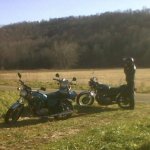
Also, I may end up riding solo on this if anyone cares to join. I'm especially interested in meeting other people who ride vintage bikes. I push my 1977 Suzuki GS750 pretty hard in turns for a vintage bike (rim/tire/brake/swingarm mods to help me with that), but I'm no knee dragger on a modern sport bike. My MAC 4-1 exhaust's muffler scrapes before I get to knee dragging low on my lightened up but still 500 lb vintage beast. really hoping to get out the next two sundays before I retire the bike for the winter and tear the engine down for a 920cc upgrade and total rebuild.
Here's a custom map link I made and saved. I am having the hardest time figuring out how you all post maps on here. Maybe the forums don't like custom saved google maps I guess.
-
I'm hoping to get two more long rides in the next two Sundays before cold weather sets in for good. I have a route mapped out that will have me in at about 7 hours riding time including the express route from Columbus to Nelsonville on 33 (just to keep the trip shorter in these limited daylight times with cold temperatures also a concern).
We rode past Burr Oak 12/01/2012 on 78, and it was better than the long stretch we did on 555 that day in my opinion, scenic, faster, more fun sweepers and twisties vs technical/rough-surfaced and non-scenic 555. that was a must ride in my opinion all the way to 377 where we split off south to catch 555 N to 669.
I figured on just taking 78 all the way to Woodsfield to catch 26 all the way to Marietta. Then I got the idea to take maybe a half hour extra according to google maps and catch 255 south to the river and then 7 to 260N to 26 to Marietta. From there I figured a nice wind-down on 550 to 33 would do it, unless I really wanted to hit 555 and some other backroads to make a long long day if I wasn't frozen from a 54 degree high temp day yet.
Looking for advice on these routes, especially with consideration to road conditions and tricky areas to watch out for since there may be damp leaves on the roads - making downhill braking into turns and cornering in general a little bit on the dangerous side. Basically my big question is - should I just ride 26 all the way from Woodsfield to Marietta, or is the short jaunt on 255 down to the river and then the boring rt 7 to 260N going to be better than the part of 26 that I cut out? Although I said I didn't think 555 was all that, I'm not into riding this far just for gentle sweepers, I just like nicer pavement and turns than 555 gave me north of 377. looking for smooth nice twisties of any speed with good surface, fun sweepers and hills, and SCENERY - cliffs and forests are a huge plus. -
-
Some of my favorites:
https://maps.google.com/maps/ms?msid=207813457435995713568.0004d301f515b6c55f4d0&msa=0
you can catch Jack Run Rd on the way home to Columbus north off of 374, to Rich Hollow Rd and/or Snortin Ridge Rd, that takes you back to Revenge Rd and Clear Creek Rd. GREAT riding.
-
Sorry guys, this 5 minute cutoff on editing a post is killing me! Can an administrator delete that last post for me, the map wouldn't post like the previous one for me, same link as the post before.
-
Sorry, learning how map links work on this forum, and learning that it will only let you edit a post within a few minutes of posting it...
riverside drive to the 3 lakes to sunbury rd (Hogback Rd is in there and about as twisty as it gets in the columbus area):
-
I think I'm gonna ride this route this weekend to get from here to my buddy's up north, the portions from Newark and looping through the Mohican area and to rt 520 are pretty darn good for this part of the state:
-
Olentangy River Road is twisty, but u have to watch out for deer, and stupid shit motorists.
Maybe you meant to say Riverside Drive? Olentangy for the most part i pretty much like a highway with traffic lights. Riverside Drive along the Scioto River, parallel to the Olentangy but west a few miles, is the good one within I270... Riverside Drive and then continue onto Klondike Rd, then you can go north and then cut east and map out a route past Delaware Lake, Hoover Reservoir, and Alum Creek Lake.
315 is pretty nice and scenic for just out of the city, the Scenic Byway portion north of 270, all the way until it merges with 23. head south and catch a few roads on the other side of the Olentangy RIver there (Chapman toTaggart Rd I've ridden, probably more good ones also)
-
Surprised no one has posted this info yet! From the Iron Pony homepage:
Iron Pony Motorsports, 5th Annual, Binte-Ji Matsuri! Come celebrate vintage show and shine! Japanese classics - and legends!
Vintage Japanese Motorcycle Club Bike Show and Swap Meet.
Admission is free
Only $5 per bike to enter your bike in the show or "contest"
Bike show - Come look at the bikes on display or bring a bike and enter the show.
Prizes for the top position in each of the 10 categories.
Motorcycle judging performed by show entrants and spectators.
Show
Categories are
Restored
Best 1960's
Best 1970's
Best 1980's
Best 1990's
Original (survivor, unrestored)
Best 1960's
Best 1970's
Best 1980's
Best 1990's
Overall
Best of show
Rat bike
Swap Meet
Various used or NOS parts, accessories and memorabilia for vintage Japanese motorcycles.
Proceeds to benefit WARM, Westerville Area Resource Ministries.
Plan to have multiple food trucks at the event…..list to follow.
Door prizes.
Saturday, 22 June, 201310:00 AM - 04:00 PM

Contact: Scott Holbrooks Email: scott@ironpony.comPhone: 614.942.0058
-
Excellent tip, thanks!
-
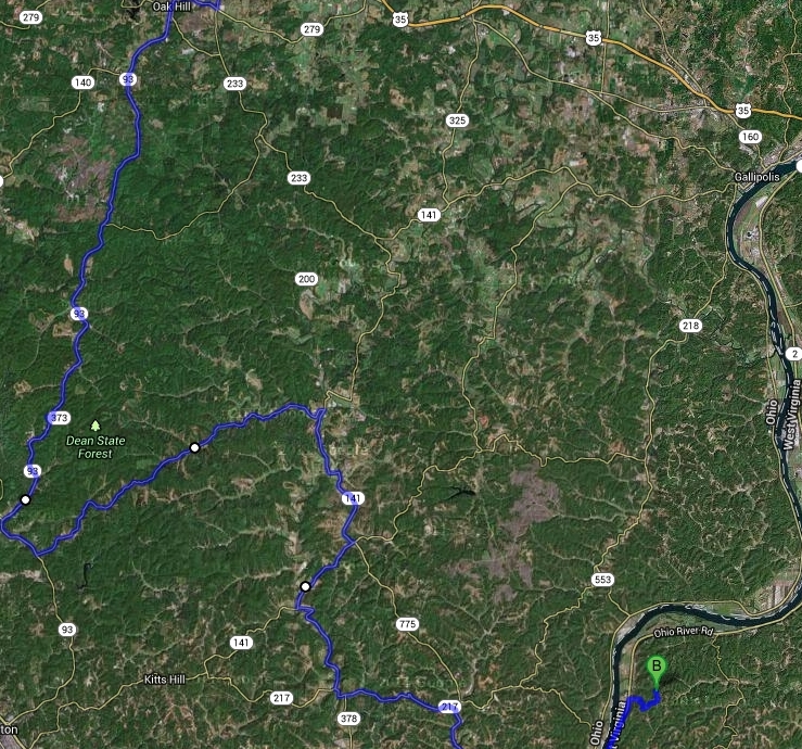
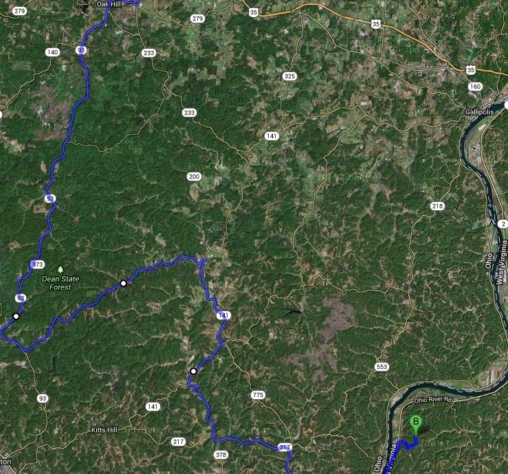
So now I've got things plotted oyt pretty good, but the question left is - Greasy Ridge Rd, or 775??? Anyone know the pavement conditions or care to comment???
-
-
http://www.motorcycleroads.com/75/1368/Ohio/Route-141-RuAl
Alright so Rt 141 through this area is at least documented as a good riding road (but no mention of how technical the curves are), but I suspect there are a lot of other really curvey and twisted roads in this area that are a blast to ride. The route I highlighted on that map appears to be through a more heavily forested area on Rt 93, which is always a big plus in terms of the scenery I like (less farms and clear cut fields, more nature) but also roads with really fun sweepers and twisties are another thing that I seek out heavily. After 93, my first tentative route takes Etna-Waterloo Rd to catch the latter part of 141 at least. After that, it takes 378 to 217 to 775.
I was also wondering if anyone has ridden GooseCreek Rd south of Hocking off of of 56 in South Bloomingville? It's right across the road from the beginning of the Chapel Ridge Rd hill climb.
-
We're riding to the Huntington, WV area Saturday morning, and the long scenic route is going to take us through Hocking on 374, and then hoping to pick up some good twisty backroads south of that. I noticed a very large wilderness area directly between Hocking and Huntington called Dean State Forest, and it looks to have some very twisty roads. I was hoping we could map out a really fun route down there, but haven't found any of those roads on any motorcycle roads type websites or even blogs or forum posts. Any ideas?
If these roads were no good, we could potentially take 328 or 278 from around Nelsonville south and stay closer to Galipolis and the north-south stretch of the Ohio River headed that way, or cross into WV at Galipolis if there are better roads on the other side of the river. Lesage, WV is the exact area we're headed, NW of Huntington.
-
My dad and I did this route last year and loved it. It really wasn't too bad to link the BRP with the New River area, and VA-311 over the mountains past Roanoke was an amazing road. We didn't get down to the Dragon or Cherohala, but there are plenty of other great roads down in that area.
Hailwood, how was that stretch of the Blue Ridge Parkway from Boone to Roanoke? I remember passing a few spots in Virginia before where I saw the BRP sign and drove on it for a short while and thought "well, that wasn't what I remembered the Blue Ridge Parkway being like...?" big rolling hills in the countryside, a nice retreat from the city, but left me thinking that would not be worth the trip for sections like that.
I'm plotting out all of my options to get together with my friends going on the ride and present them with choices.
To New River Gorge for Day 2 is a definite. After that we could:
*go east to the 3 National Forests and stay in that WV mountain area for a few days of riding and exploring, taking a leisurely time.
*OR go south on 16 to Hungry Mother/US58 The Mighty Python/421 The Snake and then head to Cherohala Skyway/Devils Triangle/TOTDragon, then head home north on a Kentucky adventure
*OR go south on 16 to HungryMother/TheSnake/US58MightyPython and for day 4 take one of three routes to VA-311 -
#1 I-81 to shave 80 minutes riding time to save for the best roads ahead, #2 north scenic detour around wytheville, or #3 hit the Blue Ridge Parkway to VA-311. The following day would be US33/SnowShoe Mtn-WV66, Smoke Hole Rd, 39/15/250 etc mountain exploration day. This last option, my initial loop plan, works best for the two guys that might have to head home to Ohio a day early, so I was trying to not go too far south, but I do want some really awesome refreshing scenery and great twisty/sweeping curve roads and hill/mountain climbs
-
Wow. Most of this is a bit further south of where we were planning to focus, but is enticing me to hit the Blue Ridge Parkway more and more. Besides US33, what other roads in that area can you recommend the most??? 250, Snowshoe, 33, smoke hole canyon, highland scenic highway, 39/55, etc????
-
Earchache, please tell me more! I watched a three part youtube video of riding "Hungry Mother," and it looked pretty awesome, and the riders only commented on one area of bad pavement over the 3 mountain or foothill ridge crossings. If you can recommend roads a lot better than that, I'd love to hear.
I'm considering focusing more time on the NE portion of WVa near the Va border, 250/33/150/39/15 etc, especially due to more scenic mountain views in that area, but WV-16 north of Hungry Mother State Park still looks like a rippin' road up and down, and even a stretch far north of that in the lesser magnitude of hills on a video of a Pontiac Solstice drive looked really great. So if there are roads way better than that, we have 5 or maybe 6 days to ride lots of them and see a lot of sights, so please indulge me with more information!
-
Cool, well thanks for the tips. Is US-58 "all that?" Maybe I should focus more on the US33 area? I want to take in amazing scenery AND hit some great technical roads with some roads full of twisties
-
I did a virtual ride-through using google streetview, & there were some pretty intense hill climbs around the Virginia section north of Marion, VA & Hungry Mother State Park, satellite view looks like mountain ranges. No mountains in the WVa portion of 16 though.
-
I've never ridden longer than about 5-6 hours of Hocking Hills State Forest or Wayne National Forest type roads on a day trip, and that's with breaks. What's everyone's opinion on this schedule in terms of fatigue from riding some very technical roads?:
day #1 9+ hours saddle time, getting into pretty technical roads the second half of the trip
day #2 4 hours white water rafting, relax and explore before and after
day #3 5 hours of twisties and mountain riding with breaks
day #4 6-7 hours riding time some mountains, some easier roads, may shorten by an hour & ride an interstate for 90 miles between worthwhile mountain regions.
day #5 4-??? hours of really great mountain riding, not a lot of necessary distance to cover, lots of mountains to explore in this area
day #6 1hr mountains, 6-7 hours head back towards SE OH & home on backroads
We could depart the afternoon before and camp out in Wayne National Forest to shave 4 hours off of the day 2 riding time and give ourselves plenty of time to rest up for the strenuous white water adventures and twisties ahead.

Route planning advice OH-78 to Woodsfield, then 26 vs 255-7-260-26???
in Daily Ride
Posted
Phone typo above, supposed to say "loop 800 & 255"