

Chuck78
-
Posts
327 -
Joined
-
Last visited
-
Days Won
2
Content Type
Profiles
Forums
Gallery
Store
Calendar
Posts posted by Chuck78
-
-
Going to try this route on Sunday hopefully, temperatures will be above 50 degrees between 11 a.m. and sunset!
What I was wondering is what enjoyable alternate routes can I take out of central Columbus to avoid 33 & get into Hocking? Hopefully there is a more fun route than 23 or 33 that will take me to the west side of Lancaster & link it to the north end of Christmas Rock Rd on my route map above. Looking at maps, all of the roads headed that direction seem to be very straight and boring
-
We were going to hit up this route today but had technical problems on one of our buddy's bikes. Maybe next weekend if it's above 50 degrees at all.
Here's revised directions that I printed and taped to my gas tank:
(33 East from Columbus)
R on US22 Cincinnati-Zanesville Rd
L on Delmont Rd SW CoHwy30
cont. L Stoney Hill Rd SW CoHwy30
L on Hamburg Rd SW CoHwy55
R on Christmas Rock Rd SW CoHwy61
L on S Broad St SR793
R on Revenge Rd SW
L on ClearCreek Rd SW CoHwy69
L continue on ClearCreek/CoHwy69
R ON 33E
R ON 374
L on 374
R on Thompson Ridge Rd CoRd36
L on 56 (R FOR GAS & backtrack)
L on Big Pine Rd across 374
R on 664 11 miles
L on 56 (GAS)
L on 374
L on 664/374
R on 374 N
R on 678
L cont on 678
L on 180
R on 374
that segments it into three sections for ease of reference while briefly taking your eyes off the road
-
I just modified that google map route to hit the secret hiking spot on Chapel Ridge Rd and then backtrack back down Chapel Ridge to 56, and hit that section of 56 you recommended (Ron), thanks! Can't wait to ride it again with the ClearCreek section and that part of 56 added, neither of which I have been on.
The directions are pretty complicated, so without some kind of handlebar mount GPS, I printed out some small barebones directions and taped to my gas tank. This revised route has many more roads on it, so it's a bit of a long list, but well worth it - helpful to color code highlight it in segments so that when you are in the middle of the directions somewhere and you take a quick glance down, you don't have to spend a lot of time searching for where you are and what road you need to look for. A handlebar mount for my smartphone and a 12V accessory outlet or hardwired 12V to USB charger on my bike would be an awesome mod for future road tripping in unfamiliar territory, however.
Just finally officially discovered the CoOhVinMoto google group, who have a discussion forum and weekly Monday night meetups here in Columbus. Mostly vintage bikes and lots of cafe racers. Really excited to hook up with this group for some rides and hangouts.
-
Here's a less detailed map that I just did using google, which gives the driving directions route format a little more standardized
https://maps.google.com/maps/ms?msa=0&msid=207813457435995713568.0004cd67b9a321034623b
-
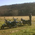
And deer trying to mate the Harleys.

I found this site a few weeks ago when trying to map out some great routes for a Hocking Hills ride. We had a really great ride, but at the end, we came up on a road closure accident where a couple on a motorcycle hit a deer in a straight residential stretch on 180/374 I think it was, and were ejected and had to be life flighted out...
Pardon my crude learning curve on plotting a map on Google for the first time, but I made a revised & extended version of the route we took, as it was a really great ride, with lots of opportunities to park and go hiking. I'll have to re-do the map in the form of driving directions sometime, but I was having trouble getting it to use the routes that I wanted vs the obvious shortest distances from A to B.
Clearcreek shows to be a great riding road on some MC route maps I pulled from the www, so I added that to the beginning of the ride. I re-routed it a bit to remain on almost all "fun" roads the entire time. We spent about 6 hours riding, taking breaks, and maybe 1-3/4 hours hiking. This route would probably be an hour longer, from Columbus.
https://maps.google.com/maps/ms?msa=0&msid=207813457435995713568.0004ccb0427124b21703a
Note that there are two pages of directions on the navigation frame to the left, and unfortunately the map only shows one page at a time, despite all of the routes being in the same general vicinity.
ENJOY!
Chuck
1977 Suzuki GS750B
fun twisties close to columbus???
in Daily Ride
Posted
Trying to go somewhere other than the usual Hocking Hills region this weekend. Are there any really fun routes around chestnut ridge Metro Park? We're looking for something closer to colimbus than hocking, with good hills and scenery. I was also considering heading towards Apple Valley & Mount Vernon. any good suggested routes?