Chuck78
-
Posts
327 -
Joined
-
Last visited
-
Days Won
2
Content Type
Profiles
Forums
Gallery
Store
Events
Everything posted by Chuck78
-
Thanks for posting this up. I've been really needing / wanting to look into new helmets that offer more wind noise protection. My exhaust is plenty loud, but when I can barely hear it due to the wind noise at 70mph+, I know that wind is further contributing to my tinnitus, eardrum damage, and future need for hearing aids.... several decades of loud music, loud guitar/bass amps, loud live bands, PLENTY of loud power tools and other mechanic / construction work noise, & lots of motorcycle wind noise to top it off. Oh yeah, & loud exhaust. I hate having to take off my helmet again after a rest stop because I forgot to put in my ear plugs! I won't do long rides at highway speed without them.
-
We can either accept the facts, or live blissfully by ignoring them and only facing what is very blatantly clear to one's own eyes without thinking any deeper about the rest of society, & how things came to be the way they are. What was that old cliche, "knowing is half the battle?" I can't recall exactly what that pertains to, but it pertains to this fairly well. Those reaping the benefits of the privilege that they are living with, without considering anyone lower than them on the social or economic ladder, and the situations that cause that, are the ones choosing to live in blissful ignorance. Often while pointing the fingers at others calling out their apparent ignorance, which is far too inappropriately blamed on the individuals, but instead, the real cause was far too often brought about by generations oppression, economic hardships, social inequality, etc.... understanding how and why things are the way they are in this society is very important, but those that have it easy choose to ignore it for the most part. They also far too often are quick to point the finger and shout the L word, accusing people of being a liberal when they are just really looking out for the betterment of humankind as a whole... I definitely don't typically side with Republicans, NEVER with that fool Trump, but I don't really side with Democrats very much either. They are the lesser of the two evils in my book. I'm not terribly religious either, I do my own thing which I believe to be *usually* the most appropriate way to live a morally just life (hey, we all make mistakes and we're all sinners to some extent or another). I did however find this very amusing:
-
The ripple effects of those massive blunders drc32-0 brought up are still affecting lives to this day... they aren't negated by the amount of charitable giving that Americans do, either. We're humans, we are erroneous in nature. The world is not likely to be a perfect place anytime soon... Unfortunately US elections ALWAYS come down to choosing between the lesser of two evils. The third party and underdog candidates may be better, but maybe they just aren't in the spotlight enough to have the muck raked up on them...
-
There have been many mentions in the news as of recently if republicans supporting Hillary... not very difficult to beat a buffoon like what Trump makes of himself... They're all politicians in the end. Although Obama is clearly the more intelligent of recent presidents, his military spending topped George W.'s military spending even though Obama wasn't making it a publicized focal point of his time in office. Same wolves, different costume. The one in the sheep's clothing isn't all that he appears but not half bad in many respects. The only difference with Obama is that he did pull off a socialized Healthcare act...the left leaning and right leaning actions don't cancell each other out however, they just add to the confused looks... Trump on the other hand... wow. I predict USA will be Hiroshima in no time if Trump were elected. He'd have every other nation of the world turning against us if he continues as he has on the election path... I noticed on my rides through the Hocking area, an immense amount of Trump yard signs. Only ONE sole hillary sign, & it was in front of a school (at least teachers are somewhat sensible and won't elect someone who has to be censored in front of children). Deep into SE OH yesterday? Not very many Trump signs, a few Hillary signs. Goes to show the demographic of the Hocking area real estate... rich people are all that can afford it down there anymore. Deeper into SE OH isn't as sought after or high priced of real estate, & maybe people down that way are more morally conscious? Anyhow I found it odd the extreme number of Trump signs around the Klankaster/Hocking area, but general lack of election signs deeper Southeast of there.
-
It's all good, just need to make sure when they are brought up on the forums that we raise the concern there are certain portions of roads like this that often bite riders pretty bad... Like the 15mph decreasing radius off camber super tight blind right hand turn heading southbound on the brand new repaving job OH-536. Located a few miles in to 536 southbound, one of the first few curves southbound that you hit after the stop sign on 536 at the Sykes Ridge Rd junction. Not a problem northbound, it's an increasing radius 15mph turn that way... Many roads that I love the most of all are roads that can be very dangerous to less advanced riders or ANY rider who let's their gaurd down... After 7.5hrs riding yesterday, I approached a turn and at that last minute read into it that thus was a much tighter turn than my 45 mph entry speed was okay with...at which time I grabbed a handful of brakes and recollected to myself "oh yeah dumbass, that was a 15mph curve warning sign you just blew past in a blur..." rider fatigue is often transparent to the rider until it is too late, luckily I have great late model ninja brakes & fantastic rubber on my 1970's superbike!
-
That's the best stretch of 83 there, southbound especially, & yes, it is just daytime weekday closures through October I believe. I take 93 north (from Zanesville) to 83 south to 209E to 658N to Guernsey Valley Rd east to Eighth St Rd S to 541 W and reverse 658 S & 209 W. Then 83S to Norfield Rd where you can veer off straight onto New Hope Rd a few miles into Norfield (It's easy to accidentally go straight onto New Hope Rd westbound, as you see the New Hope Rd pavement over the crest of the hill on Norfield, but you don't see until it is right up on you that Norfield Rd makes a hard left turn where New Hope intersects nearly head on - both take you back to 93) Did you guys ride that route? Be very careful BOTH directions on 658, I squeeled my tires quite a bit once going into the turn in question southbound, it's tighter than one would expect. I was even fully aware of that turn's sneakiness, and this was after I found out the FJR guy crashed on that exact turn. It snuck up on me, too! That was after maybe my 8th time on it, even! It's the one with the collapsing shed on the south end (on your right if heading northbound). Wonder why the shed is collapsing? Because a southbound car ran off the road through the turn and wrecked into it... a tidbit I got from talking with Denny about his buddy's crash. Denny's buddy that crashed was a former racer even... This is why I never mention that road on the forums. It can be tricky and really bite ya... a real unpredictable road, you really need to be reading every corner to the fullest extent, no letting yourself get in a comfortable rhythm... I would not take any non-advanced riders on that road unless I led them at a casual pace (a challenge for me, I try to slow it up and my newer rider buds say "you ride really really fast..." (I keep it within 5-10 of the speed limits!)
-
Come to think if it, just recently as I watched them pave 93 and 60, they ground up only the real bad sections at first, & patched them in lane width strips 50, 100, 150 feet long. Then I noticed a week later, they were paving the other end of the road entirely. Then a week or two later I noticed they ground up the patchwork sections and completely resurfaced those. If the same is true for 255 and 537, we may be seeing new pavement on both of those roads very soon as well!
-
Okay this forum doesn't like the standard ubb forum code for images... Okay again, this forum won't even let me upload a photo from a photo bucket url...
-
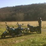
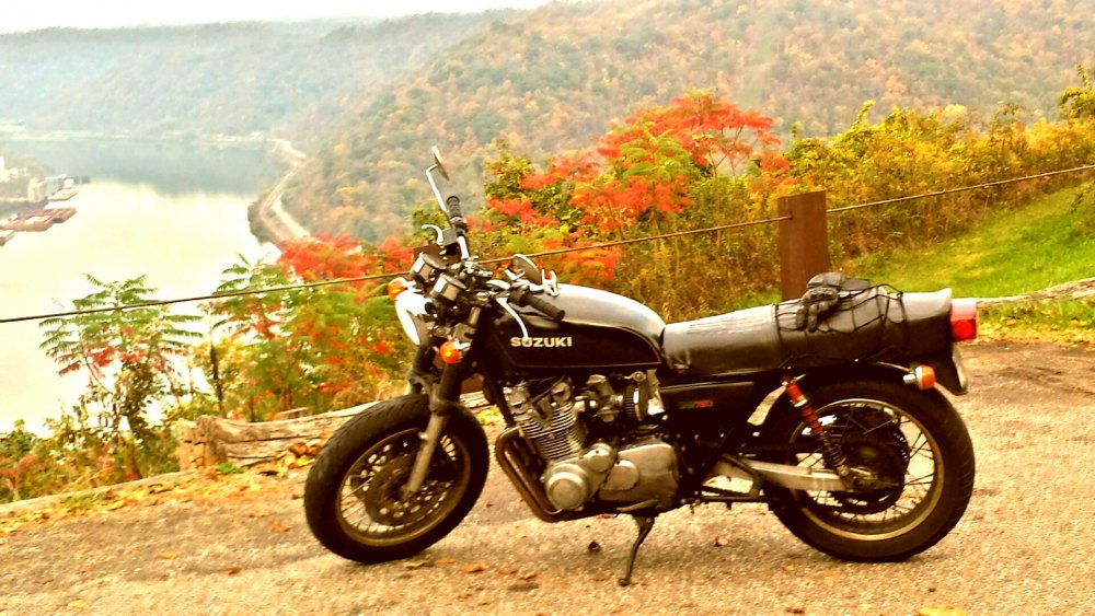
Here's 2 photos from my ride yesterday 10/19/16. One at Kiedaisch Point Park off of 536 (Long Ridge Rd to Short Ridge Rd), & the other at a recreation area in Wayne National Forest Marietta Ranger District off of 537. 2 more pics of Wayne National Forest Athens Ranger District, the Monday Creek ATV trail system, from this past Saturday
-
Pics, please?! Or links? I only snapped a quick few of a Wayne National Forest campsite area, & the obligatory shots from Kiedaisch Point Park overlook 3 miles off 536. The ridgetop vista imagery is very well burned into my brain, however... 255 about 60%-75% in southbound nearing the river I believe I'd say had the best of all views. Route 78 of course is always going to be at or near the top of the list, several Vistas from the Burr Oak State Park entrance to just past "the barn" picnic table overlook... There was one other spot where I caught some epic ridge views of huge hills off to the north that blew my mind. Maybe it was Lowell Hill Rd, maybe 530, maybe 676? Heck I can't remember. It was quite an awesome ride... Denny I may have to try to rope you into some of my rides next season. My only remaining friend who loves going on 10hr rides with me just moved to SC... all the rest of my buddies prefer 3-5hr rides at most. Riding to and from 536 the quickest rpute from Columbus plus one pass on 536 is nearly 6 hours round trip... I REALLY REALLY liked that road now... We just need to keep it civil and keep the rev's down on our bikes as to not piss off all of the residents by very audibly alerting them that bikers are fully aware that the road is up and running great again...
-
I called off work today since the foliage around Zanesville Tuesday was peaking, & the 75 degree weather today may be the last we see of that for another 5 months... rode 10 hours. Epic ride. With some of the leaves down, you can get a much better perspective of just how epicly huge some of the Southeast Ohio hills are... the foliage was the icing on the cake, until near the end of my fun roads. 536. Wow. First time it's had good pavement in a very long time. still has one section closed down to one lane with a temporary traffic light to repair the outer lane slipping down the hillside 33 from Columbus 78-685-13 78 from Gloster to 377 377 266 792 676 Watertown Rd Waterford Rd Lowell Hill Rd 60 (gas) 530 821 Dalzell to Co Rd 15 565 260 537 26 800 255 7 536... oh yeah...536 78 into the sunset at a deer watching pace 669 testing out my LED retrofit's prolific high beam 555 to Zanesville I-70 home... where I was actually more afraid of hitting deer than on the back roads. Without being able to use my high beam, and so much oncoming traffic headlight polution, you can't really see much other than the other cars. I should have kept it to backroads & a slow night time pace. 204. Overall that was a totally epic ride. 537 had a lot of patch work, as did 255, but still totally rideable. Great day.. and I actually managed to ride like a civilized person for the majority of it! Wow. A rarity...
-

Columbus to Barber Festival - 2 day route suggestions?
Chuck78 replied to Chuck78's topic in Daily Ride
Unfortunately to get down to that part of the country (Leeds, AL), most of the mountains (ALL of the big fun ones) are a good bit east, and the only interstates are west or very far west of the mountains, or very far east out of the way, no interstates north and south to take express routes to the really good stuff. Only lots of state routes that are mildly fun but a substantial travel time to each day. With only less than 12 hours of daylight each day, October makes this difficult. I did note that US-25 crosses paths with I-75 a dozen times north and south, and part of it was named the Cumberland Scenic Highway. That looks promising for a somewhat direct non interstate route, or maybe a route that you could deviate off of a little bit more but still take a nice ride there off the interstate. Any other direct north-south routes are very scarce or convoluted with lots of navigational changes. Another reason we had to take the direct route home was due to tire change negligence... the last 300 miles we were watching my the rear tire carefully on his ZRX1200, as he had worn it completely through the tread and the steel belts of the car just started showing... not prepared for the cold weather, the nasty head cold that I got also deterred me from wanting to deviate much... 45 degrees overnight in the deep south was not something I expected after 80 or 90 degree weather here and there... -
Columbus to Barber Festival - 2 day route suggestions?
Chuck78 replied to Chuck78's topic in Daily Ride
Unfortunately we ended up needing to make a lot better time than any of us had hoped for, so we did good for the time we had I suppose. Next year, if the weather is looking a little bit warmer overnight for early/mid October, I will plan to spend 1+ days in the Red River Gorge area, and 1+ days in the Cherohala Skyway area. Plan for 3-4 days travel time to get to barber in Leeds (Birmingham Alabama) -
Columbus to Barber Festival - 2 day route suggestions?
Chuck78 replied to Chuck78's topic in Daily Ride
Pre-trip bike maintenance ended up taking one more time and then I had allotted, so I hung around and waited for my friend to get off work (it's nice to have a couple riding buddies for a cross-country trek) and let them guide the way. We hit some nice roads at the edge of Daniel Boone National Forest off of I-75, and camped out for the night. Then we took i-75 most of the way down to Barber Motorsports complex, which was substantially better than I-65, which was the faster Interstate option. I-75 was actually a decent Interstate ride starting at Daniel Boone National Forest and basically everywhere south of there. Southern Kentucky was good, and Western Tennessee scenery on i-75 was much better than I expected from glancing at the Google terrain view maps. Small mountains or large hills, lots of long ridges and beautiful scenery. On the return trip, we headed into NorthWestern Georgia & hit some nice roads on Sunday evening. I don't have any names, as my friend was guiding the way & it was near dusk, so I was mostly just paying attention to the road, watching for critters, & tucking in real low since we did not have any cold weather gear, as it got down to 45 degrees overnight in Georgia! None of us had planned for such cold temperatures after the beautiful early October weather we had been having! -
Columbus to Barber Festival - 2 day route suggestions?
Chuck78 replied to Chuck78's topic in Daily Ride
To get to US421 The Snake or thereabouts (the real good roads start there and follow the mountains southwesterly) to Tellico Plains at the end of the mountains and the end of the Cherohala Skyway, to ride the best roads within a few hours of Asheville, ****there is basically NO direct express route to that area from Ohio unless I just wanted to go straight toward the US129 Dragon area, which aside from The Moonshiner 28 and the Cherohala Skyway, I am really always trying to avoid the actual Deals Gap US129 Tail of the Dragon. We may go through that area on Monday as a large group, but not on my solo trip. Looking at Google Maps, I was just blown away that there are 0 interstates really between I-77/I-64/I-79 through WV all the way across a great expanse that goes way over to I-75. Nothing for a day's worth of riding from WV interstates to the interstates that are direct route from Ohio to Alabama... I'm trying to slab it to some of the best stuff in the east, ride thst, then slab it the last 4 hours to AL... Bristol TN/NC may be a better target for Wednesday night, or maybe just book it toward the Dragon area... hitting that area on the way back, I thought solo the Back if the Dragon /Whitetop Mtn / Mighty Python route may be the better choice there but I'll be camping and riding solo and trying to make it in daylight hours on real long hauls... Wife just left 8am, took the slab and arrived in Birmingham this evening 7pm. She was riding the bike that I told her not to buy, an Evo engine'd 80cid/1337cc Harley FXR... I wrote it last night to test it out for her and determined that a 1971 CB350 Honda was probably faster and more sporty than the 1337cc Harley... I just don't understand those things! If you were to punish me for riding too fast and too aggressively, you could force me to just ride one of those and I would probably stay out of trouble as long as I don't crash it from scraping hard parts too much... grudgingly ride it... they sound cool. And haul large retired couples well (very slowly). -
Columbus to Barber Festival - 2 day route suggestions?
Chuck78 replied to Chuck78's topic in Daily Ride
If I take interstates, I can basically go directly there S-SW, or I can take 33 to WV & head south on i-77 and jump off and head to Tazewell Virginia. Then I can hit the Back of the Dragon section of Virginia 16 but I have been dying to try for a long time. After Marion Virginia, cut across on some back roads and catch Whitetop Rd and go check out the Whitetop Mountain, I believe the third tallest mountain in the east. From there I can camp after only 7.5 hours riding at Bear Claw Holler Biker Rest Stop & bike shop, or keep going Southwest on US-58 the Mighty Python, and head south out of Damascus, then continue to follow the mountains there. I found a free free campsites down that way and some $10-12 campgrounds. I could then catch a quick half of US441 The Snake, head south more toward Asheville and catch a few good looking roads through Pisgah National Forest and try NC-80 which is not terribly well known but extremely twisty. Come down through Pisgah and catch 197, then maybe take a more direct non-interstate route through the mountains and jump off on the southwestern end of the mountains and slab it 4 more hours. -
My friends are leaving tomorrow afternoon to go to Barber Vintage Festival in Birmingham Alabama. I may wait for them, or I may leave tomorrow morning early and do a full two days of Scenic riding with some Highway at the beginning and ending. Does anyone have any suggestions of good routes to take down there? There is basically nothing in the way of mountains or any good state routes that go directly that direction other than interstate, with mountains continuously southeast an hour or 3 of the route.
-
This was all done being paved 2 weekends ago when I was on it. They re-did 664 up to where 374 from old man's cave area splits off north. Didn't go past 664&374 but sadly noticed the Hawk gas station still had all pumps closed off unfortunately.
-
Great tips, thanks you all. Very much looking forward to my first trip to that area in 11 months....I only spend all winter every year dreaming of when I cam make it down to the eastern panhandle if WV! 33 was just getting repaved on the best section climbing east to the VA border on my last visit, did not got to legitimately run it due to one way traffic alternating east-west.
-
Has anyone been on 250, Moundsville to Hundred or even as far as 33? I'm looking for a nicer route than 33-50-79-33 to the Spruce Knob - Seneca Rocks area. I70 to 250 to 33 or 250 to 50 etc seems like a much more fun route. 5.5hrs on the 33 route is a great time if pressed for daylight next Thursday. If crack of dawn Friday is our departure, the scenic twisty route will likely prevail.
-
Sunday it was all fresh and no edge lines still, with no further work beyond 93 & 13. I think 669 east of here (the best stretch) is much safer eastbound, just have to watch your speed over the crests of hills as they have apexes of curves at the crests of several blind rise hills. I hit one too fast once and lifted the weight from front tire off the pavement a bit too much at the combo crest/apex on one eastbound left hander and got a nice reality check. Static sag is very critical to your suspension! I added a little more by backing off the preload slightly on the forks after that. I thought I had it set up great, but opted for more sag for those just in case moments when the road drops out from under you a lot Westbound once you get out of the forested section off of the river (where it has all of the oddly twisted/banked/off camber turns), I feel as if you get the more tricky end of the blind rises from the forested section and on westbound beyond where the merged 555 splits off south. I seldom hit it this direction, but the big blind rise hills seem to typically have more curving to the road immediately after the crest of the hill. No mishaps that I know of, but it gives me a very cautious feeling when I hot it this way. Best road in that immediate vicinity by far, just proceed overy the blind rises with caution.
-
93 repaving complete /road closure for 10 days mid August, 662, 541
Chuck78 replied to Chuck78's topic in Daily Ride
The 374 section merged with 180 is still totally shut down due to major construction. Worst bummer was the best most scenic road Clear Creek Rd was the absolute WORST I've ever seen it. The several mile stretch in the middle of bad pavement is pretty horrible by now, & it appeared to must have flooded recently, as it seemed more like a gravel road for most of this stretch, but with deteriorated pavement and a good handful of bad potholes under the gravel. Westbound seemed worst. Still I love that beautiful scenery and being able to link chipsealed Revenge Rd in the ride. I don't know if Snortin Ridge to Jack Run would get you through the road closure on 374/180 without being detoured on gravel side roads either... -
93 repaving complete /road closure for 10 days mid August, 662, 541
Chuck78 replied to Chuck78's topic in Daily Ride
669 has a new stretch of BRAND NEW pavement (no edge lines yet? from Crooksville (?) & east a ways, I believe the stretch past Perry State Forest ATV trailhead & to the next jog/merger onto another state route (8 hr ride Sunday, memory is a little foggy 2 days later). 278 just out of Nelsonville & up the awesome hill climb was repaved since the last time I hit it, when they had repaved the entire road except that northernmost big big twisty hill & into town. 56 in Hocking was great except they never paved the best stretch from 374/Ash Cave to the gas station at 664&56 in South Bloomingville. There were several concrete culvert patches across the road in curves on this best section of 56. Worst us that the only patch of gravel all day that I did not see was the one in the middle of a great curve on 56!!!! I didn't see it or feel it with my front tire, but I rolled on the throttle at the same moment mid turn, I had a major pucker moment when the rear end moved substantially (6-8"?) out from under me! Recoverable no prob, scared my buddy behind me more probably! He said I shot a bunch of gravel out from under my tire like bullets at him... WARNING - The Hawk gas station at 56&664 had all pumps shut down with signs saying "NO GAS OR DIESEL." Luckily we hadn't done more than zig zagging south through Hocking and were ok missing our planned 100mi gas stop until 56-278-Nelsonville. -
Excellent info... now if I could only make it down that far. Need to camp or hotel it overnight for that long haul. None of my buddies enjoy riding 9 hours or more like I do... don't want to burn them out!
-
93 repaving complete /road closure for 10 days mid August, 662, 541
Chuck78 replied to Chuck78's topic in Daily Ride
Also in the Hocking area, 374 is closed on the merged stretch with 180, just east of where 374 splits off south from 180. You cannot get to Jack Run Rd to use that as a nice detour. The only good bypass I know of if heading Southbound on 374 would be to take 180 East and then 678 Southwest to reconnect back on to 374. Reverse those directions if coming north on 374. I did not make it down to 56 to see if anything was happening down that way near South Bloomingville & 374 (another one of my absolute favorite short stretches of road down that way), but hopefully this Sunday.